Embed in an iframe
You can embed an interactive version of the map viewer into your webpage using an HTML iframe, as shown below:
The following expands on the introduction given in the Web Integration: iFrame page.
⚖️ Terms of Use
When embedding the map viewer using an iframe, you must comply with the Terms of Use for geo.admin.ch. Please review these terms before implementation to ensure your use case is permitted.
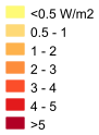
Add a legend
To add a legend of a specific layer to your embedded map viewer:
- Display the legend of the layer in the map viewer as explained in the map viewer help.
- Copy the image URL, for example, by right-clicking the legend image and selecting "Copy Image Link".
- Add an element to your HTML code displaying the image URL.
Here is an example:
<iframe
src="https://map.geo.admin.ch/#/embed?lang=en¢er=2675475,1229326.76&z=6&topic=ech&layers=ch.bfe.grundwasserwaermenutzungspotential&bgLayer=ch.swisstopo.pixelkarte-grau"
style="border: 0;width: 100%;height: 300px;max-width: 100%;max-height: 100%;"
allow="geolocation"
></iframe>
<b>Legend</b>
<p>
<img
src="https://api3.geo.admin.ch/static/images/legends/ch.bfe.grundwasserwaermenutzungspotential_en.png"
alt="Legend"
/>
</p>which looks like this in the final webpage:
Legend
Add custom elements
To add custom elements like POIs, paths, and text on top of the map viewer:
- Add the elements with the Drawing functionality of the map viewer.
- Export the elements to a KML file and save it locally on your computer.
- Upload the KML file to a publicly available web server.
- Exit drawing mode and import the KML file into the map viewer using the Import file functionality.
- Generate the iframe as you would for regular layers.
For example, to get to a result that looks like this:
follow these steps:
In the map viewer, using the Draw functionality, add some markers (red), a path (orange), a polygon (blue) and a text (green).
Export the drawing as a KML and upload the KML to
https://cms.geo.admin.ch/www.geo.admin.ch/kml/zoo.kml.After importing the KML again, a layer is added with the drawing. The generated iframe now contains the URL to the KML:
html<iframe src="https://map.geo.admin.ch/#/embed? lang=en& center=2685959.53,1248777.78& z=9.63& topic=ech& layers=KML%7Chttps://cms.geo.admin.ch/www.geo.admin.ch/kml/zoo.kml &bgLayer=ch.swisstopo.pixelkarte-grau &featureInfo=default" style="border: 0; width: 100%; height: 300px; max-width: 100%; max-height: 100%;" allow="geolocation" > </iframe>
This works with any KML, not just with those created in the map viewer.
Center on a search result
Instead of hardcoding coordinates, you can specify a search term and have the map viewer center on the first search result. The search is the same as if you would enter a term in the search bar on map.geo.admin.ch.
For example, to center the map on the address "Holzikofenweg 36, 3007 Bern":
You would pass the address to the swisssearch parameter in an iframe like this:
<iframe
  src="https://map.geo.admin.ch/#/embed?
      &swisssearch=Holzikofenweg 36, 3007 Bern"
  style="border: 0;
          width: 100%;
          height: 300px;
          max-width: 100%;
          max-height: 100%;"
  allow="geolocation"
>
</iframe>
Note: If there is more than one search result, you must pass the parameter swisssearch_autoselect=true to automatically select and center on the first search result. For example, if you search for the ambiguous "Holzikofenweg, 3007 Bern" without setting swisssearch_autoselect=true, the map will not center on any result:
Appending swisssearch_autoselect=true centers the map on the first search result (Holzikofenweg 1, 3007 Bern):
<iframe
  src="https://map.geo.admin.ch/#/embed?
      &swisssearch=Holzikofenweg, 3007 Bern
      &swisssearch_autoselect=true"
  style="border: 0;
          width: 100%;
          height: 300px;
          max-width: 100%;
          max-height: 100%;"
  allow="geolocation"
>
</iframe>
The corresponding iframe:
Embed the complete map viewer
To embed the map viewer with the search bar and other menus, replace the #/embed? with #/map? in the iframe snippet.
In an example:
This is represented by an iframe like:
<iframe
  src="https://map.geo.admin.ch/#/map?
      lang=en&
      center=2675475,1229326.76&
      z=6&
      bgLayer=ch.swisstopo.pixelkarte-farbe"
  style="border: 0;
          width: 100%;
          height: 300px;
          max-width: 100%;
          max-height: 100%;"
  allow="geolocation"
></iframe>
TIP
To ensure proper geolocation functionality, explicitly enable geolocation with allow="geolocation" to avoid issues in certain web browsers.
Example: Accessing Feature Info from an Embedded Map
This example demonstrates how to enable interaction between an embedded map and other elements on your webpage. When a user clicks on a supported feature (currently from KML or GeoJSON layers), the map sends a message event to the parent page using the postMessage API. The event is then captured by the parent page and used to display feature information outside the iframe.