URL Parameters
Adjust the parameters in the URL of the map viewer to have full control over what is shown on the map. Use the URL to reproduce what you see right now on the map viewer anywhere.
Introduction
The query string in the map viewer URL reflects what is currently displayed on the map. The query string is the part of the URL after the question mark and is composed of key-value pairs like in this example:
https://map.geo.admin.ch/#/map?
   lang=en&
   center=2660000,1190000&
   z=1&
   topic=ech&
   layers=ch.swisstopo.swisstlm3d-wanderwege&
   bgLayer=ch.swisstopo.pixelkarte-farbe
These key-value pairs are the "URL parameters" we present in the following.
TIP
The map viewer comes in two flavors:
https://map.geo.admin.ch/#/map: The full-featured web map application that you see it on map.geo.admin.ch.https://map.geo.admin.ch/#/embed: A simplified version with less menus suitable for embedding the map viewer on your webpage. See the tutorial about HTML iframes for details.
Parameter Overview
A list of all URL parameters available at map.geo.admin.ch.
| Parameter | Description | Values | Example |
|---|---|---|---|
lang | Language of the application | de, fr, it, rm, en | https://map.geo.admin.ch/#/map?lang=rm |
z | Zoom level | 0, 1, ..., 13 | https://map.geo.admin.ch/#/map?z=12 |
center | Coordinates of center of the map view in LV95. The first value is the longitude-equivalent/easting, the second value is the latitude-equivalent/northing. The two are separated by a comma. | • Easting: between 2,450,000 and 2,900,000 • Northing: between 1,050,000 and 1,350,000 | https://map.geo.admin.ch/#/map?center=2700000,1140000 |
topic | Topic selected in the menu. Topics are groups of related datasets. | blw, are, bafu, swisstopo, kgs, funksender, nga, ivs, sachplan, geol, luftbilder, wildruhezonen, vu, inspire, ech | https://map.geo.admin.ch/#/map?topic=vu |
bgLayer | Background layer | ch.swisstopo.pixelkarte-farbe, ch.swisstopo.pixelkarte-grau, voidLayer | https://map.geo.admin.ch/#/map?bgLayer=ch.swisstopo.pixelkarte-grau |
layers | The layers in use. Each layer can be configured, see layer parameters for details. | See layer parameters | https://map.geo.admin.ch/#/map?layers=WMS |
timeSlider | Sets the year of the time slider. Format: YYYY, e.g. 1981. Can be used with all "timeEnabled" levels. Special case WMS: An empty value (``timeSlider=`) means that the data for all years is displayed. | 0000, 0001, ...., 9999 | https://map.geo.admin.ch/#/map?layers=ch.swisstopo.lubis-luftbilder_farbe&timeSlider=1981 |
crosshair | Describes the type, easting and northing of a crosshair that is drawn on the map. | • Type: cross, circle, bowl, point, marker • Easting/northing: see center | (1) https://map.geo.admin.ch/#/map?center=2538700,1165890&z=6&crosshair=circle (2) https://map.geo.admin.ch/#/map?crosshair=cross,2600981,1197448 |
swisssearch | A query sent to the service behind the search bar. The map viewer shows the search result as if you typed it into the search bar manually. ℹ️ To center the map automatically on the first search result, use &swisssearch_autoselect=true, see also the iframe documentation | Any text | (1) https://map.geo.admin.ch/#/map?swisssearch=berges 37 payerne (2) https://map.geo.admin.ch/#/map?swisssearch=7.04983,46.42928 |
compareRatio | The relative position of the swipe elements when comparison mode is enabled | Floating point value between 0 and 1 | https://map.geo.admin.ch/#/map?compareRatio=0.5&bgLayer=ch.swisstopo.pixelkarte-farbe&layers=ch.swisstopo.geologie-generalkarte-ggk200 |
featureInfo | How to display the tooltip. More details in the corresponding section. | default, bottomPanel, tooltip, none | https://map.geo.admin.ch/#/map?layers=ch.bav.haltestellen-oev@features=8500010&lang=fr&featureInfo=bottomPanel |
geolocation | Whether to enable geolocation. | true, false | https://map.geo.admin.ch/#/map?lang=fr&geolocation=true |
noSimpleZoom | Whether the CTRL/CMD button must be pressed to zoom. This only takes effect in the embed mode. | true, false | https://map.geo.admin.ch/#/embed?&noSimpleZoom=true |
Layer Parameters
Layer parameters in query parameter layers describe which layers are chosen and how those layers are configured.
For example, a layer configuration in the map viewer that looks like this
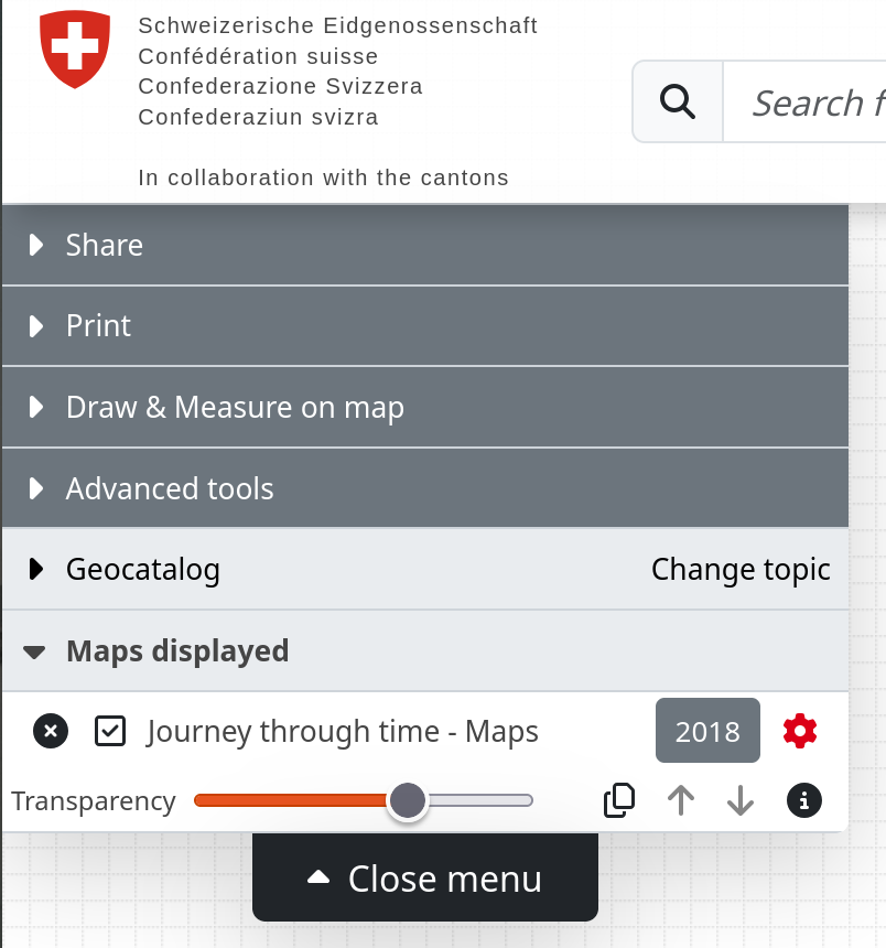
is represented by a layers query parameter like this:
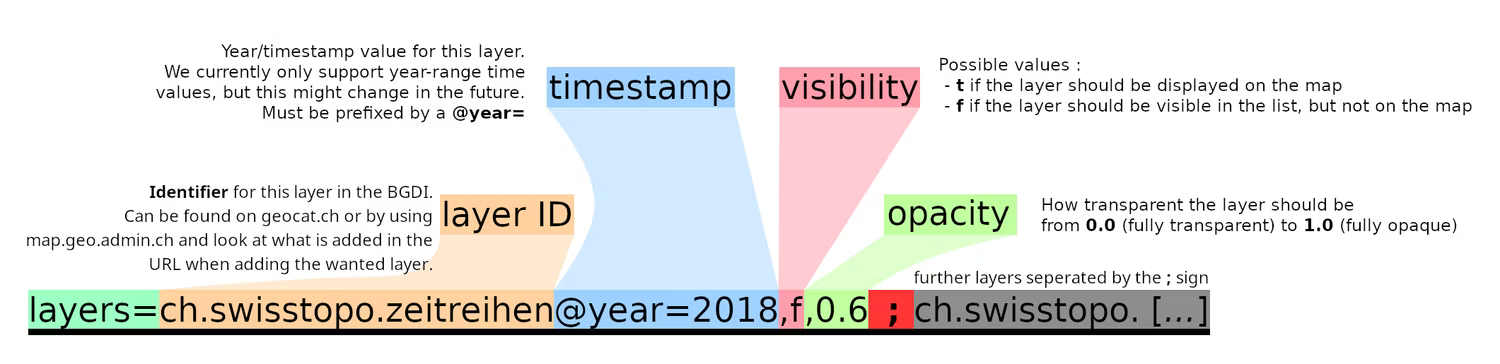
layers=ch.swisstopo.zeitreihen@year=2018,t,0.6
       ╰──────────┬──────────╯╰───┬────╯╰┬╯╰┬╯
             identifier       timestamp  │  ╰ opacity
                                     visibility
where
identifier: The "technical name" of the layer, for examplech.swisstopo.zeitreihen. You can find this identifier either in the URL when choosing the layer in the map viewer or through geocat. A full list of available layers can be listed by the/collectionsendpoint of the STAC API.timestamp: Designates the version in time of the layer. Currently you can only select a version by year using the@year=prefix.visibility:t(or empty) for "true" if the layer is displayed on the map,ffor "false" if the layer is listed in the menu but not displayed on the mapopacity: The transparency of the layer. The value ranges from 0.0 (transparent) to 1.0 (opaque).
The layer parameters are separated by comma (,). You can have multiple layers by separating them with a semicolon (;).
As an illustration:
Feature Selection
Center the map on a selected feature by using a special layer parameter: @features.
For example, a map like this:
is represented by a URL like
Multiple features are separated by a colon (:) like in this example
with URL
Tooltip
The query parameter featureInfo lets you choose from different options how to display a tooltip. A tooltip is a text box with metadata that pops up when you select a feature in the map viewer.
The available options are:
default: Places the tooltip in the default location most suitable for your device. For mobile devices, the default corresponds to optionbottomPanel, for desktop the default is the floatingtooltip.bottomPanel: Places the tooltip at the bottom of the map. This is the default location for mobile devices.tooltip: Places the tooltip over the map, as a floating element. This is the default behaviour on the desktop.none: The tooltip is hidden.