Web Map Tile Service (WMTS)
A RESTful implementation of the WMTS OGC Standard.
WARNING
We only support the GetCapabilities and GetTile operation through a RESTful API endpoint. KVP and SOAP encodings are not not available.
GetCapabilities
The GetCapabilities document provides information about the service, along with layer description, both in German and French.
https://wmts.geo.admin.ch/1.0.0/WMTSCapabilities.xml?lang=<Lang>| Parameter | Description |
|---|---|
| Lang (optional) | The language. Supported values: de, fr (Defaults to de) |
Supported Projections
Tiles are available in four supported projections:
LV95/CH1903+ (EPSG:2056)
https://wmts.geo.admin.ch/EPSG/2056/1.0.0/WMTSCapabilities.xmlLV03/CH1903 (EPSG:21781)
https://wmts.geo.admin.ch/EPSG/21781/1.0.0/WMTSCapabilities.xmlPlate-Carrée WGS1984 (EPSG:4326, in lat/lon order)
https://wmts.geo.admin.ch/EPSG/4326/1.0.0/WMTSCapabilities.xmlWGS84/Pseudo-Mercator (EPSG:3857, as used in OSM, Bing, Google Map)
https://wmts.geo.admin.ch/EPSG/3857/1.0.0/WMTSCapabilities.xml
Notes:
- Partly due to a limitation of the WMTS 1.0.0 recommendations, each projection has its own
GetCapabilitiesdocument. - The same timestamps are available in all projections. New timestamps are added to the former ones.
- The layer ch.kantone.cadastralwebmap-farbe uses a WMS service as its source.
- All layers are available at all scales. You have to check for which tileMatrixSets a particular layer is defined. Your WMTS client may either stretch the tiles from the last available level or display nothing.
GetTile
http://wmts.geo.admin.ch/<Version>/<LayerBodId>/<StyleName>/<Time>/<TileMatrixSet>/<TileSetId>/<TileRow>/<TileCol>.<FormatExtension>Use the following parameters to define your request:
| Parameter | Example | Description |
|---|---|---|
| Version | 1.0.0 | WMTS protocol version |
| Layername | ch.bfs.arealstatistik-1997 | The technical layer name. See the <ows:Identifier> tag of the layer in the WMTS GetCapabilities document. |
| StyleName | default | Only default is supported. |
| Time | 2010, 2010-01 | Date of tile generation in (ISO-8601) or logical value like current. A list of available values is provided in the GetCapabilities document under the <Dimension tag. We recommend to use the value under the <Default> tag. Note that these values might change frequently - check for updates regularly. |
| TileMatrixSet | 2056 (constant) | EPSG code for LV03/CH1903 |
| TileSetId | 22 | Zoom level (see table below) |
| TileRow | 236 | |
| TileCol | 284 | |
| FormatExtension | png | Mostly png, except for some raster layer (pixelkarte and SWISSIMAGE) |
With the tileOrigin in the top left corner of the bounding box:
| Resolution [m] | Zoom Level | Map zoom | Tile width [m] | Tiles X | Tiles Y | Tiles | Approx. scale at 96 dpi per zoom level |
|---|---|---|---|---|---|---|---|
| 4000 | 0 | 1024000 | 1 | 1 | 1 | 1 | |
| 3750 | 1 | 960000 | 1 | 1 | 1 | 1 | |
| 3500 | 2 | 896000 | 1 | 1 | 1 | 1 | |
| 3250 | 3 | 832000 | 1 | 1 | 1 | 1 | |
| 3000 | 4 | 768000 | 1 | 1 | 1 | 1 | |
| 2750 | 5 | 704000 | 1 | 1 | 1 | 1 | |
| 2500 | 6 | 640000 | 1 | 1 | 1 | 1 | |
| 2250 | 7 | 576000 | 1 | 1 | 1 | 1 | |
| 2000 | 8 | 512000 | 1 | 1 | 1 | 1 | |
| 1750 | 9 | 448000 | 2 | 1 | 2 | 2 | |
| 1500 | 10 | 384000 | 2 | 1 | 2 | 2 | |
| 1250 | 11 | 320000 | 2 | 1 | 2 | 2 | |
| 1000 | 12 | 256000 | 2 | 2 | 4 | 4 | |
| 750 | 13 | 192000 | 3 | 2 | 6 | 6 | |
| 650 | 14 | 0 | 166400 | 3 | 2 | 6 | 1 : 2’456’694 |
| 500 | 15 | 1 | 128000 | 4 | 3 | 12 | 1 : 1’889’765 |
| 250 | 16 | 2 | 64000 | 8 | 5 | 40 | 1 : 944’882 |
| 100 | 17 | 3 | 25600 | 19 | 13 | 247 | 1 : 377’953 |
| 50 | 18 | 4 | 12800 | 38 | 25 | 950 | 1 : 188’976 |
| 20 | 19 | 5 | 5120 | 94 | 63 | 5’922 | 1 : 75’591 |
| 10 | 20 | 6 | 2560 | 188 | 125 | 23’500 | 1 : 37’795 |
| 5 | 21 | 7 | 1280 | 375 | 250 | 93’750 | 1 : 18’898 |
| 2.5 | 22 | 8 | 640 | 750 | 500 | 375’000 | 1 : 9’449 |
| 2 | 23 | 9 | 512 | 938 | 625 | 586’250 | 1 : 7’559 |
| 1.5 | 24 | 384 | 1250 | 834 | 1’042’500 | ||
| 1 | 25 | 10 | 256 | 1875 | 1250 | 2’343’750 | 1 : 3’780 |
| 0.5 | 26 | 11 | 128 | 3750 | 2500 | 9’375’000 | 1 : 1’890 |
| 0.25 | 27 | 12 | 64 | 7500 | 5000 | 37’500’000 | 1 : 945 |
| 0.1 | 28 | 13 | 25.6 | 18750 | 12500 | 234’375’000 | 1 : 378 |
- The projection for the tiles is LV95 (EPSG:2056). Other projection are available, see Supported Projections.
- The tiles are generated on-the-fly and stored in a cache.
- Zoom level 24, with a resolution of 1.5m, is available in the tile pyramid but it is not currently made available through the API.
- The zoom levels 27 and 28 (resolution 0.25m and 0.1m) are only available for a few layers, e.g. SWISSIMAGE or cadastral web map. For the other layers it is only a client zoom (tiles are stretched).
- You have to use the
ResourceURLto construct theGetTilerequest. - Axis order: for historical reasons, EPSG:21781 WMTS tiles use the non-standard row/col order, while all other projections use the usual col/row order. However, most desktop GIS allow you to either use the advertised order or to override it.
- The tiles of a given layer might be updated without resulting in a new
<Time>dimension in the GetCapabilities dimension. If your application caches tiles locally, you need to invalidate your local cache for this layer. To check the latest change of any layer, use the Cache Update service.
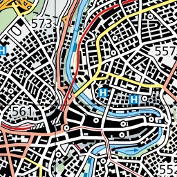
Example of a GetTile request:
curl -o demo.jpg https://wmts.geo.admin.ch/1.0.0/ch.swisstopo.pixelkarte-farbe/default/current/21781/20/58/70.jpegThe output image:
Cache Update
As noted in the GetTile section, the tiles of a given <Time> dimension might be updated for technical reasons. If you are caching tiles locally, this might result in your cache being outdated. Use the Cache Update service to query the date of the last update for a given layer. If your cache is older than the returned date, you have to clear your local cache.
https://api3.geo.admin.ch/rest/services/api/MapServer/<LayerBodId>/cacheUpdateThe latest cache update for the product SWISSIMAGE:
curl https://api3.geo.admin.ch/rest/services/api/MapServer/ch.swisstopo.swissimage-product/cacheUpdate{
"cache_type": "wmts_native",
"cache_update": "2025-06-12T08:44:38"
}Examples: OpenLayers
This OpenLayers example shows how the CadastralWebMap appears differently when loaded using a WMTS compared to a tiled WMS.
Using geo.admin.ch WMTS tiles in the new LV95 frame (EPSG:2056).