XYZ
The XYZ service provides map tiles based on specified (X, Y) coordinates and a chosen zoom level (Z).
https://wmts.geo.admin.ch/1.0.0/{LayerName}/{StyleName}/{Time}/3857/{z}/{x}/{y}.{FormatExtension}TIP
We recommend using the WMTS over the XYZ service. A WMTS provides predefined tiles like an XYZ service but a WMTS offers more functionality, like additional projections. While XYZ services are supported by most web mapping applications, WMTS is an official OGC standard.
Supported projections
The XYZ service only offers the WGS84/Pseudo-Mercator projection (EPSG:3857). This is the most commonly used projection in web mapping applications like OSM, Bing or Google Maps.
Request details
Use the following parameters to define your request:
| Parameter | Example | Explanation |
|---|---|---|
| Layername | ch.bfs.arealstatistik-1997 | The technical layer name. See the <ows:Identifier> tag of the layer in the WMTS GetCapabilities document. |
| StyleName | default | Only default is supported. |
| Time | 2010, 2010-01 | Date of tile generation in (ISO-8601) or logical value like current. A list of available values is provided in the GetCapabilities document under the <Dimension> tag. We recommend to use the value under the <Default> tag. Note that these values might change frequently - check for updates regularly. |
| z | 10 | Zoom level |
| x | 266 | Tile column (X coordinate in the tile grid) |
| y | 180 | Tile row (Y coordinate in the tile grid) |
| FormatExtension | png | The image format of the returned tiles. Most layers are provided as "png", only a few exceptions like the raster layers ch.swisstopo.pixelkarte-* and ch.swisstopo.swissimage* use FormatExtension "jpeg". See the <Format> tag in the GetCapabilities document of the WMTS. |
WARNING
The tiles of a given layer might be updated without resulting in a new <Time> dimension. If your application caches tiles locally, you need to invalidate your local cache for this layer. To check the latest change of any layer, use the Cache Update service.
Examples
Get a Single Tile
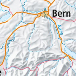
Fetch a single tile for the ch.swisstopo.pixelkarte-farbe layer:
curl -o demo.jpg https://wmts.geo.admin.ch/1.0.0/ch.swisstopo.pixelkarte-farbe/default/current/3857/9/266/180.jpegThe output image:
OpenLayers
An OpenLayers 10 example showing the Base Map layer as XYZ tiles:
An OpenLayers 10 example showing the SWISSIMAGE layer as XYZ tiles: